


Jour 4 - Refuge Deffeyes - Planaval via Col de Planaval

i20
User
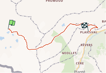


5h20
Difficulty : Very difficult

FREE GPS app for hiking
 SityTrail
IGN / Geographical institutes
SityTrail Plus
The world is yours!
About
Trail Walking of 12.8 km to be discovered at Aosta Valley, Unknown, La Thuile. This trail is proposed by i20.
Description
Meilleure carte = L'Escursionista #3 (rouge)
Du refuge de Deffeyes, prendre le chemin #16 en direction du col de Planaval. Au col, continuer dans le pierrier et retomber sur le chemin #21.
Suivre le torrent du fond. Descendre tout en bas sur le chemin /2\ (21) (21A) jusqu'à chavonnette, puis prendre la route jusqu'à Planaval.
Positioning
Comments